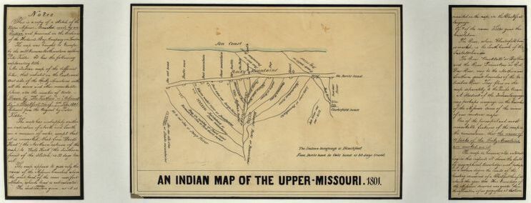
Earlier this week I came across an unusual map in the Library of Congress’ digitized collections. Part of what made this map such a fascinating find was the addendum of metadata about the map’s creation. A Blackfoot man referred to as “Ackomak-Ki” or “The Feathers” sketched this birds-eye view of the upper Missouri River and its adjoining tributaries. A single trading post appears in the illustration, labeled as “Chesterfield House,” the southernmost outlet of the Hudson’s Bay Company (HBC) and also in Blackfoot territory. To determine scale, a single notation at the bottom of the sketch reads, “From Devils head to Owls head is 33 days travel.” Blackfoot place names and their English translations specify certain mountain peaks, hills, and watersheds.
When Ackomak-Ki gave this knowledge to an explorer named Peter Fidler, it was evident to both parties that this was Blackfoot space. In the late 18th century, explorers and fur traders who entered these lands with business prospects knew the importance of learning Native languages, cultural customs, and understanding the power of kinship to facilitate trade. Over the next fifty years, the map passed through hands until its final resting place in the HBC archive in London. To prospective fur companies like the HBC, the significance of Ackomak-Ki’s sketch can be summed best by the final notation accompanying the map: “His knowledge of the Missouri sources was greater than the information of our geographers at that time.”[1].
However, more than a geographic snapshot of the upper Missouri, Ackomak-Ki’s map details Blackfoot ways of endowing land with special meaning rooted in local knowledge, myth, and history. In this sketch, the continental divide of the Rocky Mountains cuts through the center of the page, known in the Blackfoot language as Miistakis or “backbone.” Consistent with many Indigenous cultures, Blackfoot geography is constructed based on an inseparable understanding of space and time. Land is fundamental to human experiences and interactions, what anthropologist Keith Basso explains as “that close companion of heart and mind” which connects landscape to identity. [2]